Sea Creatures
Whales
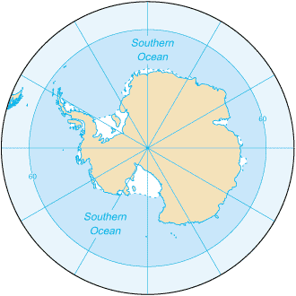
Southern OceanThe Southern Ocean as the fourth-largest of the five oceans The Southern Ocean, also known as the Great Southern Ocean, the Antarctic Ocean and the South Polar Ocean Area:total: 20.327 million sq km Natural resources:probable large and possible giant oil and gas fields on the continental margin; manganese nodules, possible placer deposits, sand and gravel, fresh water as icebergs; squid, whales, and seals - none exploited; krill, fish Environment - current issues:increased solar ultraviolet radiation resulting from the
Antarctic
ozone hole in recent years, reducing marine primary productivity
(phytoplankton) by as much as 15% and damaging the DNA of some fish;
illegal, unreported, and unregulated fishing in recent years,
especially the landing of an estimated five to six times more
Patagonian toothfish than the regulated fishery, which is likely to
affect the sustainability of the stock; large amount of incidental
mortality of seabirds resulting from long-line fishing for toothfish Ports and terminals:McMurdo, Palmer, and offshore anchorages in Antarctica Terrain:the Southern Ocean is deep, 4,000 to 5,000 m over most of its extent with only limited areas of shallow water; the Antarctic continental shelf is generally narrow and unusually deep, its edge lying at depths of 400 to 800 m (the global mean is 133 m); the Antarctic icepack grows from an average minimum of 2.6 million sq km in March to about 18.8 million sq km in September, better than a sixfold increase in area; the Antarctic Circumpolar Current (21,000 km in length) moves perpetually eastward; it is the world's largest ocean current, transporting 130 million cubic meters of water per second - 100 times the flow of all the world's rivers lowest point: -7,235 m at the southern end of the South Sandwich Trench Natural hazards:huge icebergs with drafts up to several hundred meters;
smaller bergs and iceberg fragments; sea ice (generally 0.5 to 1 m
thick) with sometimes dynamic short-term variations and with large
annual and interannual variations; deep continental shelf floored by
glacial deposits varying widely over short distances; high winds and
large waves much of the year; ship icing, especially May-October; most
of region is remote from sources of search and rescue Geography - note:the major chokepoint is the Drake Passage between South America and Antarctica; the Polar Front (Antarctic Convergence) is the best natural definition of the northern extent of the Southern Ocean; it is a distinct region at the middle of the Antarctic Circumpolar Current that separates the cold polar surface waters to the south from the warmer waters to the north; the Front and the Current extend entirely around Antarctica, reaching south of 60 degrees south near New Zealand and near 48 degrees south in the far South Atlantic coinciding with the path of the maximum westerly winds Disputes - international:Antarctic Treaty defers claims, but Argentina, Australia, Chile, France, NZ, Norway, and UK assert claims (some overlapping), including the continental shelf in the Southern Ocean; several states have expressed an interest in extending those continental shelf claims under the United Nations Convention on the Law of the Sea (UNCLOS) to include undersea ridges; the US and most other states do not recognize the land or maritime claims of other states and have made no claims themselves (the US and Russia have reserved the right to do so); no formal claims exist in the waters in the sector between 90 degrees west and 150 degrees west |
Environment - current issues:increased solar ultraviolet radiation resulting from the
Antarctic ozone hole in recent years, reducing marine primary
productivity (phytoplankton) by as much as 15% and damaging the DNA of
some fish; illegal, unreported, and unregulated fishing in recent
years, especially the landing of an estimated five to six times more
Patagonian toothfish than the regulated fishery, which is likely to
affect the sustainability of the stock; large amount of incidental
mortality of seabirds resulting from long-line fishing for toothfish Environment - international agreements:the Southern Ocean is subject to all international agreements regarding the world's oceans; in addition, it is subject to these agreements specific to the Antarctic region: International Whaling Commission (prohibits commercial whaling south of 40 degrees south [south of 60 degrees south between 50 degrees and 130 degrees west]); Convention on the Conservation of Antarctic Seals (limits sealing); Convention on the Conservation of Antarctic Marine Living Resources (regulates fishing) note: many nations (including the US) prohibit mineral resource exploration and exploitation south of the fluctuating Polar Front (Antarctic Convergence), which is in the middle of the Antarctic Circumpolar Current and serves as the dividing line between the cold polar surface waters to the south and the warmer waters to the north. Economy - overview:Fisheries in 2006-07 landed 126,976 metric tons, of which 82% (104,586 tons) was krill (Euphausia superba) and 9.5% (12,027 tons) Patagonian toothfish (Dissostichus eleginoides - also known as Chilean sea bass), compared to 127,910 tons in 2005-06 of which 83% (106,591 tons) was krill and 9.7% (12,396 tons) Patagonian toothfish (estimated fishing from the area covered by the Convention of the Conservation of Antarctic Marine Living Resources (CCAMLR), which extends slightly beyond the Southern Ocean area). International agreements were adopted in late 1999 to reduce illegal, unreported, and unregulated fishing, which in the 2000-01 season landed, by one estimate, 8,376 metric tons of Patagonian and Antarctic toothfish. In the 2007-08 Antarctic summer, 45,213 tourists visited the Southern Ocean, compared to 35,552 in 2006-2007, and 29,799 in 2005-2006 (estimates provided to the Antarctic Treaty by the International Association of Antarctica Tour Operators (IAATO), and does not include passengers on overflights and those flying directly in and out of Antarctica). Transportation - note:Drake Passage offers alternative to transit through the Panama Canal
|